


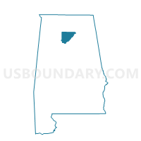
Walter Community Center, Cullman County, Alabama
About
Outline

Summary
| Unique Area Identifier | 521616 |
| Name | Walter Community Center |
| County | Cullman County |
| State | Alabama |
| Area (square miles) | 17.60 |
| Land Area (square miles) | 17.39 |
| Water Area (square miles) | 0.21 |
| % of Land Area | 98.80 |
| % of Water Area | 1.20 |
| Latitude of the Internal Point | 34.12803840 |
| Longtitude of the Internal Point | -86.67497390 |
Maps


Graphs
Select a template below for downloading or customizing gragh for Walter Community Center, Cullman County, Alabama


Neighbors
Neighoring Voting District (by Name) Neighboring Voting District on the Map
- Berlin Community Center, Cullman County, AL
- Blountsville, Blount County, AL
- Center Hill Community Center, Cullman County, AL
- Holly Pond Fire Dept., Cullman County, AL
- Welti Fire Station, Cullman County, AL
Top 10 Neighboring County Subdivision (by Population) Neighboring County Subdivision on the Map
- Simcoe CCD, Cullman County, AL (7,373)
- Blountsville CCD, Blount County, AL (7,330)
- Holly Pond CCD, Cullman County, AL (4,539)
- Welti CCD, Cullman County, AL (2,309)
Top 10 Neighboring Unified School District (by Population) Neighboring Unified School District on the Map
Top 10 Neighboring State Legislative District Lower Chamber (by Population) Neighboring State Legislative District Lower Chamber on the Map
Top 10 Neighboring State Legislative District Upper Chamber (by Population) Neighboring State Legislative District Upper Chamber on the Map
- State Senate District 17, AL (157,178)
- State Senate District 9, AL (144,554)
- State Senate District 4, AL (123,291)
Top 10 Neighboring 111th Congressional District (by Population) Neighboring 111th Congressional District on the Map
Top 10 Neighboring Census Tract (by Population) Neighboring Census Tract on the Map
- Census Tract 9642, Cullman County, AL (7,373)
- Census Tract 505, Blount County, AL (7,329)
- Census Tract 9653, Cullman County, AL (4,539)
- Census Tract 9652, Cullman County, AL (2,309)